HANOVER SUBMERGED
Eleazar Wheelock Would Have Searched in Vain 25,000 Tears Agofor Present Site of College
GENERATIONS of Dartmouth men have walked the campus paths and hiked over the plains of Hanover and Norwich unaware of the interesting fact that they were treading on the floor of an extinct lake. But the modern student is instructed about the lake in his classes in Evolution, and the 200 men who take the course in General Geology each year are well acquainted with minute details of its history and the events which brought about its replacement to-day by the Connecticut River.
The lacustrine conception, which is a comparatively recent one, we owe to Prof. J. W. Goldthwait who first described the evidence for the old lake in 1910 shortly after he first came to Dartmouth to take charge of the Geology department. The previous geologist at Dartmouth, Prof. Charles ("Type") Hitchcock, and his able young assistant, Warren Upham '71, collected a wealth of observations which are now seen to substantiate the theory of the lake rather than their own original interpretations, and recent research has fully corroborated the new conception.
The events here described date back to comparatively recent geological time at the close of the last glacial period, some 25,000 years ago. All New England in common with the northern half of North America had for thousands of years previously been covered with a great ice cap, like that to-day in Greenland so thick that it overtopped the 6285-foot summit of Mt. Washington, so heavy that it pressed down the crust of the earth beneath it a few thousand feet, and so massive that its volume in combination with the smaller ice cap in Europe lowered the level of the ocean approximately 300 feet. The coming of a world-wide warmer climate caused the ice edge to melt back from its southern limits on Long Island, and in this slow northward retreat of several thousand years the Connecticut Valley was progressively laid bare. The farmed and forested river valley of to-day was then submerged in the waters of a great glacial lake which had at its expanding northern limits the white wall of the ice sheet, while its shores were fringed with the earliest migrating plants of subarctic type like those growing to-day in Labrador.
This first great stage of glacial waters in the valley is known as Lake Hitchcock, in commemoration of Prof. Edward Hitchcock of Amherst College, the father of Prof. Charles Hitchcock of Dartmouth. Edward, who was one of the leading geologists and men of science in the first half of the 19th century, and an early president of Amherst, recognized the lake where he studied it in Massachusetts as early as 1818, and gave it considerable attention in his writings.
Lake Hitchcock owed its existence to two causes. First, the valley in the vicinity of the narrow gorge of the river at Middletown, Connecticut, was obstructed by a natural dam of glacial deposits which alone would have produced a lake. Second, the weight of the ice pressed down the crust of the earth so that the floor of the valley actually sloped northward toward the ice, effectually preventing the free flow of a river. As a result the lake began to appear as the ice uncovered Middletown, and it expanded into Massachusetts and Vermont and New Hampshire with increasing depth as the ice withdrew. In Vermont and New Hampshire the lake was only two or three miles wide, but in the broad lowland of Massachusetts and Connecticut it attained a width of ten or twelve miles and contained several large islands that are now lofty hills. In this broad southern portion of the lake which was earliest uncovered and where the sweep of winds was greatest the waves cut deeply into the island hills. West of Hartford, Connecticut, the cliffs and boulder-strewn terraces carved by the waves are well developed along the ancient shore. North of Connecticut the best features making the shore line are the deltas built by tributary streams where they joined the lake. These deposits occur as terraces high on the sides of the valley and close to the streams that built them. Their flat tops mark approximately the water level, and excavations reveal their characteristic inner structure of horizontal gravel beds overlying steeply dipping beds of sand.
WHEN THE elevations of the deltas and wavecut terraces are collected it is found that the Hitchcock shore has remarkable continuity, showing that as long as the lake lasted it did not fluctuate in level. However, this shore which was originally horizontal like shores of modern lakes, now rises in elevation toward the north due to uplifting of the earth's crust since the glacial period. In fact these measurements offer the only clew to the manner and amount of this crustal movement. From an elevation of 135 feet above sea level near Middletown the shore rises northward 3.3 feet per mile in Connecticut and 4.6 feet per mile in central New Hampshire and Vermont, so that at Hanover the same shore reaches 657 feet. It is there marked by a delta of Mink Brook three miles east of the college where the road to Etna joins the Lebanon road. A person embarking in a boat at that point could have passed around a great island between Hanover and Lebanon, formed by the confluent estuaries of Mink Brook Valley and Mascoma Valley, and then continued
on an unbroken sheet of water for 150 miles southward to Middletown. SOME OF OUR most valuable records of the lake and the retreating ice sheet are derived from the deposits which formed in the deep water. As the ice melted its waters worked downward through crevasses and developed a mighty subglacial river which followed the axis of the valley and emerged at the front of the ice at the bottom of the lake. At its point of emergence this confined river dropped the gravel and cobbles it was carrying, and these deposits built up a continuous gravel ridge or "esker" as the ice-front withdrew. The valley contains an almost continuous esker for the 24 miles between Windsor, Vermont, and Lyme, New Hampshire, except where the present river has cut through it or removed it. Occom Ridge is the best known section of the esker in Hanover, and Occom Pond near by marks the place where an iceberg was stranded and mired in the outpouring debris.
THE FINER sediment coming from the subglacial river spread itself on the sides of the esker and for miles down the lake. In summer, when melting of the ice was greatest, a thick layer of silt was deposited; in winter, when no melting occurred, the clay settled. Thus thick deposits of silt and clay built up the extensive plains of the lake floor, each yearly layer known as a "varve," and each varve beginning at the ice front for that year and overlapping the varve of the year preceding—like the shingles on a roof. A count of the varves gives the age of the lake just as the age of a tree is measured by its rings.
The thicknesses of the varves depend on the summer temperature which controlled the amount of ice melted annually, and since these thicknesses vary proportionally all over the lake floor it is possible to correlate varves in clay banks miles apart. Where the bottom varves at two localities can be measured and their difference in age determined, the rate of ice retreat between the two localities can be computed. Thus it has been found that at Hanover the retreat was rapid and averaged 1265 feet per year. In 1921 the Swedish geologist, Ernst Antevs, measured all the available clay sections in the Connecticut Valley and found an almost unbroken record of 4100 varves recording as many years ice retreat from Hartford, Connecticut, to St. Johnsbury, Vermont.
After enduring for at least 4000 years, Lake Hitchcock was suddenly drained in perhaps a year's time and replaced by a lower lake level. This new lake has been named Lake Upham for Warren Upham of the class of '71, who was probably the most notable geologist to have ever graduated from Dartmouth. In the 5 years following his graduation and while assistant to Prof. Charles Hitchcock, Upham surveyed and mapped the water-laid glacial deposits in all the principal New Hampshire valleys; he discovered the great Connecticut Valley esker; and he published what is still the most complete and detailed report of the glacial deposits in New Hampshire. Upham lived to return to his 60th reunion and to visit and inspect the shorelines that now bear his name. He died in the spring of 1934.
THE DRAINAGE of Lake Hitchcock occurred when the ice front had reached Lyme, New Hampshire, 10 miles north of Hanover. West Lebanon had been uncovered only 72 years before this event, and Hanover only 55 years as shown by the varves. In a dozen sections that have been measured within 20 miles of Hanover the varves of the Hitchcock period are suddenly terminated all in the same year either by no further sediment—showing that there the lake floor was exposed above the Upham water level—or they are capped by a thick sand bed —spread by streams advancing their mouths toward the new lake shore—and this sand is capped by many more thin varves belonging to Lake Upham. So sudden was the drainage of Lake Hitchcock that the reduced water pressure destroyed the subglacial river, probably by causing the collapse and obliteration of the ice tube, and thus the growth of the great 200-foot esker ridge was terminated at Lyme. The Hitchcock drainage is still much of a mystery but is believed to have been due to erosion of an obstruction at Middletown, Connecticut. In Massachusetts and Connecticut the valley was immediately replaced by a river, but at Turners Falls, Massachusetts, the subsiding waters were caught upon ledges which controlled a strip of river as far as Charlestown, N. H., north of which was the new Lake Upham.
Lake Upham has shore lines 90 feet lower than the Hitchcock shores, but parallel with them. It expanded northward to Littleton and beyond St. Johnsbury, reaching within 30 miles of Canada and attaining a length of 85 miles and depths of 200 feet. Its waters extended into several of the larger tributary valleys to give it roughly the shape of a branching tree. (See illustration.) The drainage and replacement of Lake Upham by the present river was partly due to an uplifting movement of the earth's crust begininng about the time the ice front reached Littleton, and partly to erosion around the ledges which controlled it at Turners Falls. It was the most important lake in the upper Connecticut Valley, and endured for at least 600 years at Hanover and 1600 years near Haverhill and Woodsville.
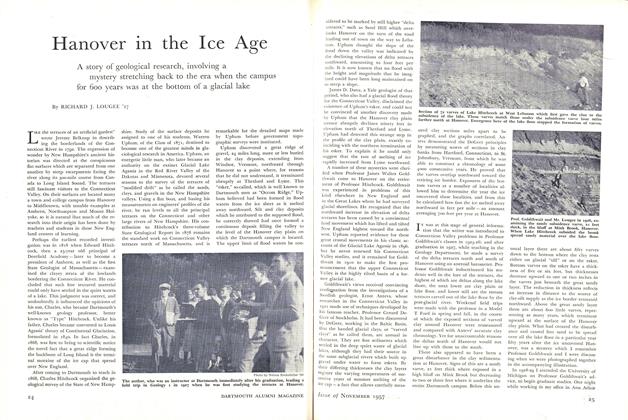
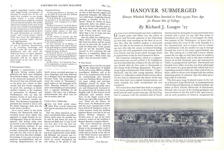
TOURING THE brief 55-year period of Lake Hitchcock Hanover enjoyed its most profound submergence. The water line at an elevation of 657 feet would have stood 112 feet above the center of the campus so that only that part of the Baker Library tower above the middle of the clock face and the uppermost twelve feet of stonework on the College Tower would have projected above the water. When the waters subsided 90 feet to Lake Upham Mink Brook extended its mouth three miles westward from Etna and built a new delta. A fragment of this remains forming the terrace known as "Sand Hill," from which the first view of the college is obtained on the road from Lebanon. When standing on the flat delta top an observer's eyes are close to the 565-foot elevation of the old Upham water level which would follow the line of small monitor windows just below the roof of Alumni Gymnasium, passing across the top of the front door of Baker Library and twenty feet above the center of the campus. Had the founder of the college arrived in Hanover in those ancient times he would have found dry ground only on the small rocky island formed by Observatory Hill.
View of Hanover from the front of the Mink Brook delta of Lake Upham, with the upper line showing the approximate depth of Lake Hitchcock (elevation 657 feet) and the lower line that of Lake Upham (elevation 565 feet).
Map showing late-glacial conditions in New England when Lake Hitchcock was at its maximum extent in the Connecticut Valley. Lakes occupied the Hudson and Merrimac Valleys and Long Island Sound; the continental shelf of southern New England was dry land; and the sea covered much of the coastal belt north of Boston.
Second map showing the same region when Lake Upham was at its maximum extent, controlled by ledges on the river at Turners Falls, Mass. The subsiding waters of Lake Hitchcock were caught upon these ledges which controlled a strip of river as far north as Charleston, N. H., where the southern end of Lake Upham was formed.
Left, the author inspects a section of the varves at Mink Brook which record the 55 years of Lake Hitchcock. Center, Lougee and Professor Goldthwait are shown at work near the varves of Lake Hitchcock (lower right-hand corner) overlaid by the sand bed which marks the sudden subsidence of the lake. Right, the author uncovers thick silty varves which were formed at Hanover when the ice stood four or five miles to the north.