IGY
The International Geophysical Year, Opening July 1, Is Man's Greatest Scientific Effort to Know His World "At a time when we are inching along toward international political understanding, this cooperative effort in which 46 [now 58] nations join together to observe and study geophysical phenomena, comes as reassuring news." — W. G. MACNUSON, Chairman, Subcommittee on Independent Offices and General Government Matters, U. S. Senate Appropriations Committee, 84th Congress, Second Session.
ON July first, one of the most significant scientific ventures in history will commence operation. During the past seven years, every major nation on earth has joined in the planning of a program of geophysical observation in which mankind as a whole will put the earth in its hand. In contrast to other programs designed to impel men to work together, the International Geophysical Year 1957-58 (IGY), at a cost of several hundred million dollars, will be incredibly cheap for the fruits of cooperation it has produced even from its planning alone. In large measure unfettered by political and national constraints, scientists of all nations have worked together to plan a unified program of investigation and discovery in which the results will be deposited in world archives, available to all scholars.
Russia was slow to join, but after it had become clear that the free world was going ahead, and that the project was destined to be eminently exciting and successful, she undertook responsibilities commensurate with her means.
It is paradoxical that science offers mankind at once its greatest threat and its greatest hope: the threat residing in the potential prostitution of the magnificent discoveries in the atomic nucleus, and the hope residing in the compulsion for truth which is latent in scientific exploration. Men imbued with the search for natural truths, find it easy to stand aloof from political and national struggle. These are the true "one-worlders" and it is natural that they should find their one constraint, the earth itself, an object of compelling interest.
Geographical discovery, once it began in earnest, moved forward until all but the polar regions had been charted. Concomitantly as they went, explorers observed the weather, the seas, the earth's magnetism and other terrestrial phenomena. The inaccessibility of the polar regions posed the last great challenge. In recent years, urged on by strategy in political power struggles, and facilitated by man's fabulously advancing means, the occupation of the Arctic has been accomplished. In contrast, man still knows relatively little about the Antarctic because of its much smaller strategic importance and much greater challenge to means.
IGY has been organized by the Comité Spécial de l'Année Géophysique lnternationale (CSAGI), an ad hoc body established by the International Council of Scientific Unions (ICSU). ICSU operates thirteen international scientific unions in the various fields of science. The entire structure is non-political, deriving support from adhering Countries through their academies of science or similar representation. Although greatly aided by UNESCO since that organization came into existence, dependence upon UNESCO subventions for existence has been carefully avoided because of the political character of that organization. At the general assemblies of the unions, the scientists of the world talk science, oblivious of their individual national affiliations. Each builds a global circle of friends of common interest and respect, never more than three of four days from one another by air letter.
The concept of an International Geophysical Year for a coordinated effort by all nations of the world to conduct synoptic observations on a global scale has been a logical extention of the work accom- plished in the First and Second Polar Years of 1882-83 and 1932-33 respectively.
The First Polar Year, in the midst of the most active era of Arctic exploration, produced the first synoptic data on the meteorology, geomagnetism, and aurora of the region. Fifteen expeditions were sent out, eleven to the Arctic and four to the Antarctic. One of the most notable scientific achievements was the map of isochasms produced by Fritz describing the geographical dependence of auroral activity. The map has not been substantially modified to this day.
The Second Polar Year came at the dawn of radio exploration of the ionosphere. There were no ionograms then although the separate identity of the E- and F-regions had been discovered. The undertaking produced an awakening to the phenomenon of solar particle precipitation and the concentration of the resulting effects in the polar regions. Fifty-five special stations were set up, 43 in the Arctic, five in the Antarctic, and seven in low and middle latitudes.
Although the First and Second Polar Years were separated by fifty years, the accelerated advance of science suggested to L. V. Berkner in 1950 that a program even 25 years after the last would be tardy. From his suggestion, today's prodigious program has grown. The first full-scale assault on the Antarctic has been undertaken. To the Arctic and Antarctic have been added the equatorial zone, where unique phenomena have been found, and four meridional chains of stations along W75°, E 10°, 110°, 140°.
The assault on the Antarctic is now in full swing because of the need to install stations in local summer and because of the commencement of IGY in local winter. Dave Nutt '41, Dartmouth geographer, and Don Guy '38 of the Associated Press discuss this last great geographical challenge in other articles in this issue.
The scientific fields of study included in the IGY program are:
1. Meteorology
2. Oceanography
3. Glaciology
4. Longitudes and Latitudes
5. Rockets and Satellites
6. Solar Activity
7. Geomagnetism
8. Aurora and Airglow
9. Ionospheric Physics
10. Cosmic Rays
11. Seismology
12. Gravimetry
In addition to routine programs of observation, a calendar of world days and world meteorological intervals has been established. A world warning agency has been set up at Ft. Belvoir, Virginia, which receives solar, geomagnetic, and radio propagation patrol data by telecommunication and, on the basis of these, calls special alerts during which times observations in many programs will be increased. Testing of the world-wide communication and warning system has been in progress for several months.
The United States Congress has appropriated 38 million dollars of special funds for American participation and it is estimated that the value of the logistic support provided by the Department of Defense is several times as much again.
THE details of the program are complex beyond imagination and not more than a glimpse at these can be given in the words which follow.
The atmosphere is responsible for a number of factors crucial to life: oxygen, moisture, insulation against deadly radiation from the sun. No property of the atmospbere, however, is more important than its motion. Winds distribute heat from the tropics to other regions, transport moisture from the oceans and drop rain on the continents, remove polluted air from the cities and bring in clean air. The general circulation of the atmosphere keeps the air moving rapidly over the globe day in and day out, year in and year out. In a windless world, the tropics would become intolerably hot and the rest of the planet unbearably cold. The parched continents would become dust; cities would suffocate.
One of the major aspects of the meteorological program has to do with this mass movement of the atmosphere between the tropics and the polar regions and with the circulation around the world. The meridional chains of stations will reveal the circulation patterns and the exchange of heat between the tropics and the poles, and such special features as the jet streams.
Storms forming off the east coast of Asia may cause a cold wave to surge over the United States a week later, which in turn may create a new storm in mid-Atlantic and subsequent floods and snow avalanches in Europe. Clearly, the prediction of local weather depends upon the dynamics of the whole world's weather.
Sea-level is about a foot higher in local summer and autumn than in winter and spring. This change is undoubtedly due to the transport of water between the equatorial and polar regions by the great ocean currents. Practically nothing is known about ocean currents except at the very surface of the sea. The deep currents may be of great importance in long-range weather forecasting, particularly because of the exchange between the Antarctic and low latitudes. Nobody knows whether it takes one year or 10,000 years for deep water to travel from the Antarctic up to the equator and back again.
The fertility of the oceans depends upon the exchange of water between the deeps and the waters near the surface; that is, the amount of fish and other food we can get out of the ocean is finally limited by the rate at which the ocean overturns and thereby fertilizes itself.
The development of atomic energy will probably result in the production of unbelievable quantities of radioactive substances and somehow we must dispose of these. The ocean is a very great hole in the ground, and its currents might spread out radioactive substances to such an extent that they would be harmless. Whether this would be possible or not depends upon how fast the deep water moves and how it mixes with water near the surface.
Glaciologists want to know if the world's glaciers are receding. They occur at all latitudes, even in the tropics in South America, Africa, and New Guinea. If the 10,000-foot-thick ice caps of Greenland and Antarctica were to melt, coastal cities and lands would be submerged, arid and verdant areas would be readjusted, and the ice-locked lands of polar regions would become free.
In the longitude and latitude program the dual-rate moon-position camera will be used to make simultaneous exposures of the moon and surrounding stars. With this camera, the moon's position is held fixed relative to the stars during the exposure. Several observations of the moon on a single night by one station will determine the position of the station with reference to the center of the earth. From the position values of a sufficient number of stations. the figure of the earth may be obtained.
The United States and Russia will launch the earth's first man-made satellites - those of the United States in low latitude orbits and Russia's in pole-to-pole orbits. The United States plans to launch six satellites, each about 25 inches in diameter and weighing 22 pounds. At a height of 300 miles, the satellites will travel at 18,000 miles per hour, encircling the earth in an hour and a half. With luck, each satellite is expected to stay aloft for several weeks. They will measure air density, temperature, and pressure; meteoric particle density, magnetic field strength, and solar radiation, as well as greatly improve our knowledge of the relative positions of the continents. There is presently a possibility that information on some of these positions may be as much as 300 feet in error.
Many geophysical phenomena of fundamental importance occur in the high atmosphere of the earth. Geomagnetic disturbance, aurora and airglow, ionospheric physics, and cosmic ray fluctuations are all dominated by solar activity. This activity rises to a sharp maximum and slowly subsides every eleven years. IGY has been chosen to coincide with a maximum of activity.
Solar flares, specific events observable on the sun, correlate directly with geomagnetic disturbances, the occurrence of aurora, ionospheric storms, and cosmic ray showers. A remarkable audio-frequency radio-wave phenomenon known as the dawn chorus also correlates with shortterm solar-terrestrial disturbance. To unravel this complex of interdependent effects, extensive programs in all of these fields are planned while a continuous patrol watches the sun. Enough solar observatories are available so that neither darkness nor cloud will interrupt the patrol.
Disturbance effects are concentrated in the polar regions and extremely little is actually known so far about the correspondence of events in the Antarctic to those in the Arctic. Magnetometers, auroral spectographs and all-sky cameras, cosmic ray detectors, and ionosphere sounders, all spread liberally over the earth will surely go far to solve the puzzle of solar-terrestrial disturbance.
Near the end of IGY, a new age will commence in commercial aviation. The public will then be flying twice as high and twice as fast as now. From the serenity of a reclining seat at 40,000 feet, the concept of IGY will be easy to grasp.
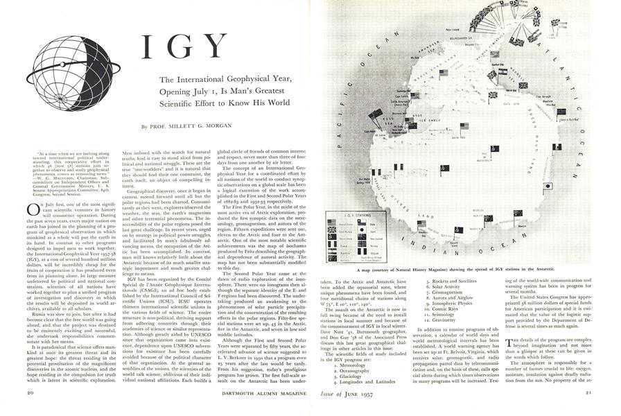
A map (courtesy of Natural History Magazine) showing the spread of IGY stations in the Antarctic.
Acknowledgment: I have drawn program description material from a special report by the National Academy of Sciences to the United States Senate Committee on Appro- priations. - M.G.M.